Israel’s Borders, just like the world map, have been, and still are, constantly changing. The geography of twenty years ago is vastly different from that of today. To refer with any accuracy to the territory of Israel, or any other nation, one must specify the time period.
There is a great territorial difference between the land promised to Abraham and his seed, and that land eventually occupied by ancient Israel. Furthermore, the boundaries of Israel fluctuated markedly during Israel’s Old Testament history. In modern times the borders of Israel have had major modification at least four times since 1948.
The literal, political State of Israel in relation to the promises made to the patriarchs is of central interest to Bible students. The current boundaries of Israel constitute a highly controversial international issue. A review of the Bible record of these boundaries may clarify for us some of these issues.
The promises
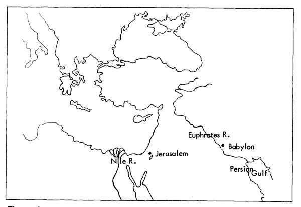
God’s definitive statement to Abraham is in Genesis 15:18: “Unto thy seed have I given this land, from the river of Egypt unto the great river, the river Euphrates”. We may designate this stretch of territory between the two rivers as the Promised Land, recognising that political Israel never has incorporated such an expanse into its administration. In the times of the Judges (1 Chron. 5:9) and David (1 Chron. 18:3) the indication is that only irregular Israelite activity extended in the direction of the Euphrates area.
As a convenient distinction we may call the land occupied by Israel the Holy Land, with varying borders and changing masters.
The northern border
A perusal of a map illustrating the location of the river Euphrates in relation to Jerusalem will disclose that an arc from slightly below east to just short of due north describes a prospective border for the Promised Land of about one thousand miles. Assuming that the Mediterranean coast provides the west border, a small gap of about one hundred miles lies due north of Jerusalem between the sea and the Euphrates.
The present border between northern Syria and southern Turkey is a natural line here.
Israel occupies Canaan
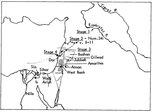
As Israel approached Canaan limited objectives capable of expansion were placed before the nation. Moses recited God’s intentions in Deuteronomy 1:7: “go to the mount of the Amorites, and unto all the places nigh thereunto, in the plain, in the hills, and in the vale, and in the south, and by the sea side, to the land of the Canaanites, and unto Lebanon, unto the great river, the river Euphrates”.
The Amorites were east of Jordan, the Canaanites were west, Lebanon was to the north and the Euphrates north and east of there. All twelve tribes were expected to cross Jordan. However, in Numbers 32, Reuben, Gad and half of Manasseh proposed that their inheritance consist of Gilead and Bashan, embracing the land of the Amorites and round about, as expressed in Deuteronomy 1:7. This was conditionally granted.
Two chapters later we have something of a puzzle. Moses designated the land of Canaan as Israel’s inheritance, presumably without limiting the possible inheritance to wider fields. Now the north border is determined in Numbers 34:7-9 as a series of names which is a boundary through the middle of what we now know as Syria, well short of the Euphrates and enclosing Lebanon (see map). The east border, verses 10 to 12, angles back towards the Lebanese mountain foothills, possibly excluding Damascus, descends to the Sea of Galilee and follows the Jordan to the Dead Sea. Numbers 32 has already instructed us to add Gilead and Bashan to this area.
Thus the northern boundary of the Holy Land retracted from the river Euphrates to middle Syria. We may call this development Stage Two.
Tyre and Sidon
Joshua in chapter 13 began the task of dividing the land between the nine-and-a-half tribes. The north border country was allocated in part to Asher, whose assigned territory included Tyre and Sidon (19:28,29). This is as far north as Joshua ever attempted to allot territory. The subjugation of this territory was set as an immediate and reasonable objective, no doubt with conquests further north as a later goal never achieved. This limited objective we may designate as Stage Three.
In fact Tyre and Sidon remained unconquered for Israel’s entire Biblical history, and Israel’s north border commenced as far down as coastal Dor, angling northeast to Mount Hermon, and thence east to Bashan. This Stage Four represented the final effective north border, nowhere near the Euphrates and well south of that envisaged in Numbers 34.
The south border
The contraction of the north border through various stages will help us to understand a similar situation affecting the southern boundary. The lower border of the Promised Land in Genesis 15:18 is defined as “the river of Egypt”. Is this river the Nile, or a wadi so named in the Sinai Peninsula?
As in English, the Hebrew has a variety of nouns to describe a flowing body of water. River, stream, creek, brook, canal, rivulet and torrent are equally variously defined in Hebrew. The two Hebrew words we are concerned with are nahar and nachaL
Nahar Biblically describes a substantial river, and is used of the Gihon, Euphrates, Abana and Pharpar. That usage fixes the substantive nature of the river referred to in Genesis 15:18, where nahar occurs three times and equates the nature of” the river of Egypt” with that of the Euphrates.
Nachal describes a wadi-type river, and is employed of the Jabbok and the Anion. It is the word used in Joshua 15:47 to describe the southwest extent of the lands of Judah: ” . . . unto the river of Egypt, and the great sea, and the border thereof”. In two widely separated occurrences of “the river of Egypt” two different Hebrew words are used for river. Genesis describes a substantial body of water; Joshua is referring to a brook. There are good reasons for proposing that Joshua was referring to the Wadi Arish, a coastal valley midway across the north Sinai Peninsula, also named the Brook of Egypt or the River of Egypt on some early maps.
The significance of the careful choice of Hebrew words in the Scriptures will be grasped by reference to the staged retraction of the northern boundaries. Applying the same principle, this proposition emerges: the Promised Land extends to the river Nile, but the land available for allocation by Joshua only extended to the Wadi Arish.
The first section of this proposition can be successfully tested.
Sihor
There are several place names describing the southwest limits of Israel’s land. Sihor or Shihor is one: “This is the land that yet remaineth from Sihor, which is before Egypt . . . ” (Josh. 13:2,3; cf. Isa. 23:3; Jer. 2:18).
The mainstream Nile has its own unique Biblical word, yeor. (The Jordan, remarkably, is never Biblically described by any Hebrew word as any sort of river. It is its own entity, the Jordan.) However, the mighty Nile breaks down into as many as ten delta outlets into the Mediterranean Sea. Each one of these is properly described as nahar. Hence Strong’s Concordance and Hasting’s Dictionary suggest that Sihor is the Biblical name for the eastern branch of the Nile delta, and the Genesis promise uses the appropriate nahar.
The Red Sea
Further support for this proposition comes from Exodus 23:31: “And I will set thy bounds from the Red sea”. The swampy area through which the Suez Canal now runs was known as the Red or Reedy Sea. The eastern branch of the Nile delta emptied into a lake in this area.
We therefore have a conjunction of three factors; a nahar, or substantial waterway, known as Sihor, emptying into the Red or Reedy Sea system. The Bible records these three identifying features as the lower border of the Promised Land. There can be little doubt that the east branch of the Nile delta is intended.
The faithless behaviour of Israel eventually forced Joshua to allocate a much smaller parcel of land. Originally Judah was offered land to the nachal or Brook of Egypt (Josh. 13:3). If this be the Wadi Arish ( and this cannot be tested) this south area was withdrawn from Judah and given to Simeon (19:1-9), a result of dividing a land of contracting borders. Between Sihor and the Brook of Egypt is a coastal town called Sin, from which the name Sinai is derived. It lies inside the Promised Land, but Ezekiel 30:15 refers to it as “the strength of Egypt”. The land is promised, but Israel attained it in modern times only to give it back to Egypt.
Israel today
Contemporary Israel does not occupy as large an area as ancient Israel, let alone the area originally envisaged in Numbers, Deuteronomy and Joshua. Much world opinion regards Israel’s present occupation of the West Bank as illegal. Some call for an Israeli withdrawal from the West Bank in return for internationally recognised and secure borders for Israel. But what constitutes Israel’s legitimate borders?
In ancient times Israel occupied not only the West Bank but also the East Bank—Gilead and Bashan—now northern Jordan. She was allocated Tyre and Sidon by Joshua—now southern Lebanon—but never obtained them. Several times God declared that Lebanon was available for Israel. Numbers 34 nominates half of Syria as Israeli territory. The promises to the fathers specify the land from the Nile to the Euphrates as the Promised Land. Surely the Israel of today is but a fraction of the nation that is to be. The prophets foretell positive developments.
Gilead and Lebanon
The current destruction of Lebanon as a viable nation is paving the way for the fulfilment of Zechariah 10:10. Referring to returning Jews, God remarks: “I will bring them into the land of Gilead and Lebanon; and place shall not be found for them”. Note that the fate of northern Jordan is linked to that of Lebanon. Zechariah’s last remark is amplified in Isaiah 49:19,20: “For thy waste and thy desolate places, and the land of thy destruction, shall even now be too narrow by reason of the inhabitants. . . The place is too strait for me: give place to me that I may dwell”. The prophecy foresees a flood of returning Jews crowding the available land.
Lebanon is being prepared to receive a flood of returning Jews. Northern Jordan will also be used for the same purpose. Ezekiel 39:28 adds: ” . . . but I have gathered them unto their own land, and have left none of them any more there”. No more Jews left outside Israel means a possible addition of 14 million more Jews to Israel, an unbearable pressure of people in present borders. God not only foretells events, but also provides the reasons why they occur.
The prospect is for expanded borders of Israel far beyond the area currently occupied by Israel and beyond the area anciently occupied. This will lead to continuing upheavals, hysterical Arabs, media hype, and world outrage in quarters where God’s purposes are completely ignored.
Whatever we may think of the moral and spiritual values of the contemporary nation of Israel, our reaction needs to be tempered by the knowledge that God’s long-range purposes are being worked out in them as He sees fit. God’s tactical plan is to expand Israel’s population and, as a consequence, its borders. In the process His judgements on Israel’s Arab neighbours for their sins, reaching back 3,500 years, will continue to be poured out. As Bible students, we can expect further developments along the lines of our forefathers’ expectations, who looked for a political establishment of Israel in the Holy Land. That process, which we have had the privilege of witnessing in its initial stages, is by no means complete. An Israeli bridgehead has been established, with every firm assurance that the tenuous borders of today will fill out to Biblical expectations of long ago.
The filling out of the borders of Israel will be a long and painful process. The message of Ezekiel 39, that all Israel have returned to the land, comes after the defeat of the Gogian invasion of the mountains of Israel, which, in turn, comes after the subjection of all of Israel’s immediate Arab neighbours. The flow of violent and distressing news from the Middle East is by no means near an end.
Israel, Egypt and Assyria
A final view is provided by Isaiah 19:24,25: “In that day shall Israel be the third with Egypt and with Assyria, even a blessing in the midst of the land: whom the Lord of hosts shall bless, saying, Blessed be Egypt My people, and Assyria the work of My hands, and Israel Mine inheritance”. A glance at the map will confirm that the territory from Egypt, through Israel, to Assyria envelops all the land from the banks of the mighty Nile to the farther shores of the Euphrates and more. That highway joins the two great rivers. It all fits together so well. After all, the Bible does make logical, good, common sense, does it not?